Two Ways Atlanta Can Legalize a Bigger, Better Midtown
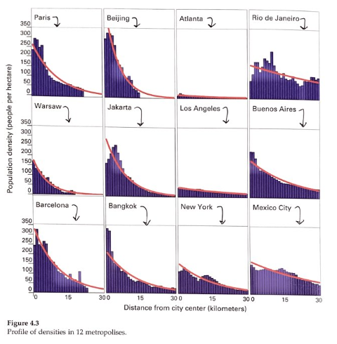
Atlanta’s growth has, for decades now, been a quintessential example of Sunbelt sprawl. While the city has some tall buildings downtown, the metro area is more an amalgamation of smaller activity centers. When measured by population density, its urban core is less dense than even downtown Los Angeles, as Alain Bertaud’s recent book makes clear with the image below.

Source: Alain Bertaud, Order Without Design, p. 64, December 2018
But pressure is building for Atlanta’s downtown to grow. Norfolk Southern recently announced a move to Midtown, bringing more than a thousand jobs to the streets beside Georgia Tech. The last few years have seen Midtown’s street parking lots give way to buildings at the maximum allowed local density, a sign that Atlanta is feeling the same pressures of gentrification that fuels angst in other big cities. Fortunately, Atlanta has planned for this. Their comprehensive plan calls for “high-density commercial” development in all of Midtown, with areas of “high density” and “very high density” residential buildings nearby.
Yet including an idea in a comprehensive plan is different from changing city zoning codes to allow for planned development. Below are a few changes Atlanta might want to consider if it wants Midtown to grow into the dense, transit-oriented neighborhood it envisions.
1. Simplify and merge zoning districts
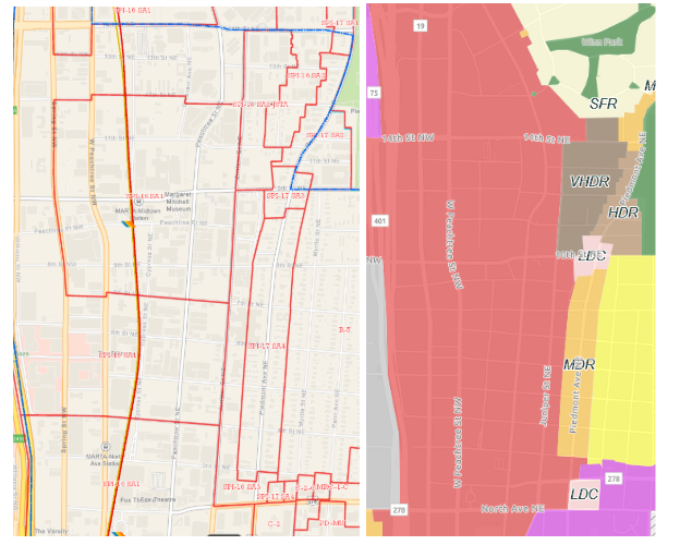
A simple reading of Midtown’s zoning code reveals a pair of neighborhood-specific zones that cover most of the core of Midtown. Both are codified as “Special Public Interest”, or SPI, zones, that exist only in one neighborhood and can be changed without altering zoning in the city at large. SPI-16 regulates the areas within a few blocks of Midtown’s rail lines, while SPI-17 regulates areas along Piedmont Street further east.

Left: SPI-16 and SPI-17 with subareas. Right: Midtown future land use. Source: City of Atlanta
On the surface, this seems like a reasonable policy decision. Special zoning near transit can allow for higher population densities than less developed neighborhoods can support. Problems arise when one reads the statute and realizes that both SPI-16 and SPI-17 are split into multiple subareas—and one of SPI-16’s subareas, Subarea 2 is further divided into the “Juniper Street Transition area” (JSTA) and “non-Juniper Street Transition Area”.
The city’s comprehensive plan calls for all of Subarea 2, JSTA and non-JSTA alike, to become “very high-density residential”, the densest residential development typology currently planned for the Atlanta region. Similarly, SPI-16’s third subarea is only half a block wide, controlling density in an area where views are already protected by other regulations. These rules also limit density in all 3 of SPI-17’s subareas. Transition areas within subareas in neighborhood-specific zones make for complicated land use regulations that can change dramatically from block to block. In a fast-developing area, needlessly complicated rules mean that property owners struggle to understand how much their land is worth, sometimes leading them to sell for less than they would if they fully understood their property’s development potential.
2. Allow bigger buildings around Midtown’s transit stations
Atlanta officials have long hoped for Midtown to be a natural extension of the city’s downtown office building core. The area is one of the best served by transit in the city, with trains every five minutes on MARTA’s Red and Gold lines and all of SPI-16 and 17 within half a mile of one of the stations. Heights are somewhat limited in SPI-17 due to view protections, but SPI-16 at the core of midtown does not have height limits at all.
Rather, Atlanta limits density with a system of floor area ratio (FAR) rules that force developers to trade height for extra open space on their properties. Each point of FAR is equal to the area of the property, so a 3 FAR building could be three stories covering the full lot, or six stories covering half the lot. They can earn more allowed FAR by including amenities like ground floor retail and affordable housing, but these amenities may not be appropriate for every project. As it stands, the area allows for and regularly sees construction of three to four story residential buildings, and five to six story commercial buildings without employing any bonuses.
An alternative would be to increase by-right FAR while retaining the system of density bonuses should it makes sense to offer them. Raising FAR limits as high as 15, including bonuses, would add approximately 100 million buildable square feet across Midtown.
What would that mean for Midtown? If the area’s 60-40 bias toward commercial development is maintained, it would add 40 to 50 million square feet of office space, 10 to 20 million square feet of retail space and 50,000 residential units at an average of 800 square feet per unit. It would add space for 2 to 3 people to work for every new residential unit created, maintaining job balance while adding enough downtown units to put Atlanta more in line with Los Angeles in Bertaud’s density diagram above. A table with alternative housing and commercial mixes for the zone may be found here.
At the end of the day, aligning existing zoning with future plans is a political choice for Atlanta policymakers. Simplification of the zoning map would lend certainty and clarity to property use guidelines for landowners. Adding transit-accessible jobs and housing along underused rail lines would make better use of existing infrastructure investments. It would bring more people to the urban core, supporting more retail and office jobs and growing the tax base, all by simplifying rules and extending the right to build a little higher into the air. Sounds like a good deal to me. Whether the people of Atlanta agree is for them to decide.
Catalyst articles by Nick Zaiac
